-
A Study in GPR Mapping and Concurrent Excavations at Gradina Rat, Brač, Croatia
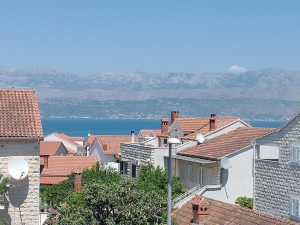
A GPR program was conducted on a hilltop on the island of Brač, Croatia to assess whether this area was a fort, or a defensive structure, as had been suggested by people for many years. Its location, the sight-lines from the ridgetop, and the surface artifacts all supported this idea perhaps dating from the Bronze Age. The first goal of the project was to collect many profiles around the raised edge of a “basin” on the hilltop, which was hypothesized to have been walls of the fort. Instead, the GPR profiles showed resistant limestone bedrock, and no indication of constructed…
-
Additional Analysis on GPR Mapping of the Hominid Trackway, Laetoli, Tanzania

Previously I wrote a paper on the mapping of the hominid tracks at Laetoli Site S, which connected the trackway from two excavations conducted in 2016. In the search for other tracks in other grids, I mapped other features that are not footprints, but could be confused with them. This short paper is that analysis, which discovered and mapped small channels, which were likely water runoff gullies in the T-7 surface. This is not as important as the tracks themselves, but could be confused with trackways features, and need to be considered in any GPR analysis. Here I have also…
-
GPR Analysis of the Mortuary Features at Pillar Sites in the Turkana Lake Area, Kenya

Four sites with standing pillars, often in clusters or circles, which are estimated to be 8,000 years old, were constructed on the margin of a large freshwater lake in northern Kenya in the early Pliocene. Limited excavations of one of them showed abundant human remains associated with these monuments. GPR surveys were carried out within and around the pillars to map possible subsurface features. It was found that skeletal remains, associated pottery and many other artifacts are found within well-defined excavated areas that are about 1 meter or more in depth. The GPR analysis was used to calculate the area…
