-
A Test of Geophysical Prospecting for the Detection of Prehistoric Canals on the Gila River Reservation, Arizona
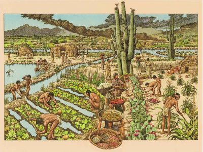
This report documents a project to apply geophysical prospecting techniques at known locations of prehistoric canals in the Gila River Reservation. The project goal was to test the ability of several geophysical prospecting techniques to image buried canals in the Gila River floodplain. Four geophysical prospecting approaches were tested: ground penetrating radar, seismic reflection imaging, magnet gradiometry, and electrical conductivity.
-
Thoughts on the Integration of Slice-Maps and Reflection Profiles in GPR Analysis
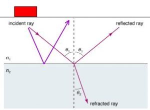
Any comprehensive interpretation of GPR data must include the integration and analysis of both amplitude slice-maps and two-dimensional reflection profiles. Often one method can yield results that the other cannot, producing important insights. One example from Ireland shows how slice-maps produced very useful images of subtle post molds, which outlined a crannog in a pond or lake. These molds were invisible in the 2-D profiles. From Long Island, New York, the amplitude slice-maps were very busy and confusing, and only through detailed analyses of reflection profiles were cellars of historical houses visible.
-
Geophysical Investigations at Carrizo Stage Stations, Anza Borrego Desert State Park, California
Geophysical investigations were conducted at three Carrizo Corridor Stage Stations within the Anza Borrego Desert State Park to search for buried objects and structures associated with historic occupation of these sites. Field surveys were conducted on March 21-23, 2001 at Carrizo Creek, Palm Spring, and San Felipe Stage Station. Three geophysical techniques were employed: ground penetrating radar (GPR), electromagnetic conductivity (EM), and total magnetic field measurement (MAG).
