
by Lawrence B. Conyers
Ground-penetrating Radar Studies at the HAMMER Test Facility, Richland, Washington
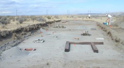
The HAMMER geophysical test bed in Richland, Washington provides a facility to compare ground-penetrating radar (GPR) reflection images to known archaeological features in the ground. Simulated buried features including stone cairns and rings, burials, trash middens, artifacts and other materials were buried at depths from 12-36 inches in sandy ground and then re-buried with the…
6 responses to “Ground-penetrating Radar Studies at the HAMMER Test Facility, Richland, Washington”
-
The point about water content is an interesting one and I have recently had the opportunity to look at a site where in abnormally dry (drought) conditions last year a 500 MHz GPR survey did not produce useful reflections and as amplitude slices was remarkably uniform. However, after rehydration this spring, electrical resistance survey revealed substantial lateral variations that would have normally be expected to be visible to GPR, not just in terms of reflectance but also ground coupling. Proof maybe that in certain circumstances a site could be too dry for GPR, although I haven’t investigated this site in more detail, nor do I intend to do a second GPR survey for comparison…
-
Thanks for the comments Martin. I spent some time with this problem 20 years ago and in some cases re-collected data 5 or 6 times during different times. Sometimes in winter, summer, after a rain with no rain for many months. Everything was different! Also did a test with GPR in a place on coastal Georgia with a large tidal range, and found some very interesting differences between high and low tide! The short story is that sometimes rain can be differentially moved through sediment and soils. Sometimes in very permeable materials, it quickly moves down to be “ponded” in features we care about, like burned house floors or other impermeable units. Elsewhere after the rain all I saw was “blobs” of differentially retained water that made no sense at all regarding how those changes in RDP reflected waves. Once in Japan a Kofun burial chamber was invisible one day, and two days later after a typhoon came through, it stuck out like a sore thumb! In that case it was volcanic ash soil that was very permeable. In New Mexico I got only half the energy penetration when the ground was wet, than when dry. In that case it was because the water that was in contact with the clay created a highly conductive layer, and attenuated the energy. In Central America I got 4 meters of energy penetration with an 80 MHz antenna in March, and when done again in June (as the rainy season was a month old) only got about 1 meter! Lots of variables! I have published most of these examples in my books, and if you want some copies, just write!
-
-
Your comment re the “distribution of water and differences in water saturation” hit home for me. Many parts of Australia that I work in, I believe that the amount of seasonal rainfall is not enough to affect the GPR response.
-
You would be surprised Andrew how a little bit of water can make a big difference! These differences need not be “seasonal” but can be daily or even hourly… Always keep in mind the water and its distribution. Because it is water that is the major factor in the velocity of radar waves. And it is a change in the velocity of radar waves that produces reflections, with the greater the change in velocity, the higher the amplitude of the reflections. I just did a quick calculation, which is easy to do (I have it in one of my books if you are interested). If you take just sand with a 25% porosity and it is mostly dry sand, the overall RDP wil be about 4-5. If you take only 1/3 of that porosity and put water in it, the overall RDP of the medium goes up to between 12 and 13! That may not seem like a big difference, but it plays a huge role in both the velocity of the radar waves in that material, and also the amplitude of the reflections within it.
-
-
I read through this article and it makes me think about test sites in
general. I think that there should a be a few test sites around the
country that are essentially identical for archaeological or any other
near surface geophysics testing. I would want them to be about the size
of a football field at minimum with controlled access but not on
government of military facilities. I would want to use them for training
and also where all equipment manufacturers should collect data with
their new instruments in these ideal controlled conditions.I would make sure to design the sites to have controlled drainage so we
could do testing in either dry or wet conditions but have an idea
whether water was ponding on top of buried features.Does the HAMMER site still exist?
I built two test sites in 2009 I think at Fort Bliss in El Paso, TX and
Fort Wainwright in Fairbanks, AK.Geophysics for Military Construction Projects
https://apps.dtic.mil/sti/citations/ADA531964I remember there being issues at the test site at CERL in
Urbana-Champaign, IL not having accuract depths measured prior to burial.I have also built several other test sites at other facilities.
I would get really annoyed when young employees or interns who I was
paying would not collect data on the test sites when I told them to. I
told them I’m paying your salary and it should take this long to collect
data over the test site with each type of instrument. Then I would show
them what good data looks like.Just my rant for today.
-
I fear that these test sited have gone out of favor, as Ryan has mentioned. The one in Illinois was made by magnetic people who didn’t know that depth was important! And I don’t think anyone has used Hammer since we were there in 2003….Ryan has some others too, which I think are still important. I know people in the UK who are thinking these things about doing controlled tests with GPR and I hope they do and let us know what they find out.
-
Leave a Reply