

Tag: Ground-penetrating radar
-
Any comprehensive interpretation of GPR data must include the integration and analysis of both amplitude slice-maps and two-dimensional reflection profiles. Often one method can yield results that the other cannot, producing important insights. One example from Ireland shows how slice-maps produced very useful images of subtle post molds, which outlined a crannog in a pond…
-

Under the Aboriginal Land Rights Act, we have responsibilities and a statutory role to: (a) Take action to protect the culture and heritage of Aboriginal persons in the council’s area, subject to any other law; and (b) Promote awareness in the community of the culture and heritage of Aboriginal persons in the council’s area. This…
-
Aboriginal people in Cape York Peninsula area of Australia have strong emotional attachment to cemeteries and the burial places of their ancestors. Often, as at Mapoon, in northern Queensland, many such places are unmarked and neglected. The graves can be difficult to identify on the ground surface, either because they were never marked, or because…
-

Geophysical investigations were conducted at the La Purisima Mission State Historic Park to understand potential impacts due to the proposed development of a new visitor’s center. The portion of La Purisima State Park studied is located near the park entrance, just north of the intersection of Purisima Road and Mission Gate Road, in Lompoc, California.…
-
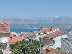
A GPR program was conducted on a hilltop on the island of Brač, Croatia to assess whether this area was a fort, or a defensive structure, as had been suggested by people for many years. Its location, the sight-lines from the ridgetop, and the surface artifacts all supported this idea perhaps dating from the Bronze…
-

Previously I wrote a paper on the mapping of the hominid tracks at Laetoli Site S, which connected the trackway from two excavations conducted in 2016. In the search for other tracks in other grids, I mapped other features that are not footprints, but could be confused with them. This short paper is that analysis,…
-

Four sites with standing pillars, often in clusters or circles, which are estimated to be 8,000 years old, were constructed on the margin of a large freshwater lake in northern Kenya in the early Pliocene. Limited excavations of one of them showed abundant human remains associated with these monuments. GPR surveys were carried out within…