

Tag: GPR
-
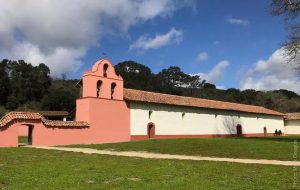
Geophysical investigations were conducted at the La Purisima Mission State Historic Park to understand potential impacts due to the proposed development of a new visitor’s center. The portion of La Purisima State Park studied is located near the park entrance, just north of the intersection of Purisima Road and Mission Gate Road, in Lompoc, California.…
-
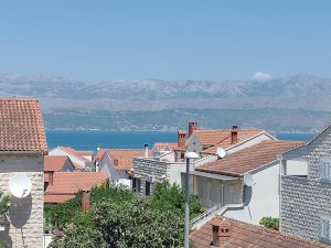
A GPR program was conducted on a hilltop on the island of Brač, Croatia to assess whether this area was a fort, or a defensive structure, as had been suggested by people for many years. Its location, the sight-lines from the ridgetop, and the surface artifacts all supported this idea perhaps dating from the Bronze…
-

Previously I wrote a paper on the mapping of the hominid tracks at Laetoli Site S, which connected the trackway from two excavations conducted in 2016. In the search for other tracks in other grids, I mapped other features that are not footprints, but could be confused with them. This short paper is that analysis,…
-

Four sites with standing pillars, often in clusters or circles, which are estimated to be 8,000 years old, were constructed on the margin of a large freshwater lake in northern Kenya in the early Pliocene. Limited excavations of one of them showed abundant human remains associated with these monuments. GPR surveys were carried out within…
-
The ephemeral remains of buildings in a Late Period Costa Rican village proved challenging for GPR mapping because little remained but foundation stones and compacted earth floors. Those features had been disturpted over the last 800-900 years by erosion, flood deposits, root action and slumping of the ground. Standard amplitude mapping proved to be beneficial…
-

Many GPR reflection profiles were collected using a canoe on a freshwater lake in the Rocky Mountains. Excellent radar wave penetration was measured, using both 270 and 400 MHz antennas. Reflection traces were placed into space using GPS and individual profiles were interpreted, with the lake bottom and other reflections digitized for three-dimensional mapping. It…
-

by Lawrence Conyers and Denisse Argote | Integrating a lidar relief map with GPR subsurface mapping, accompanied by locating known and inferred surface structures allowed for the reconstruction of a Late Classic Period walled compound. It was found that this enclosure is not perfectly rectangular, was partially dismanteled in the past, added on to in…